From PhysOrg.com:
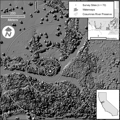
Lasers are providing scientists with new tools for mapping, protecting, and restoring bird habitat along rivers. In a paper published in the October issue of Ecological Applications, scientists from PRBO Conservation Science and the Information Center for the Environment at UC Davis used aerial laser technology known as LiDAR (short for Light Detection And Ranging) to predict where different bird species occur in the Cosumnes River Preserve in central California, USA.
EcoTone newsletter from the Ecological Society of America writes:
Laser-imaging bird habitats
A paper out in the October issue of Ecological Applications puts forth a new use for light detection and ranging technology, or LiDAR: the prediction of bird habitats.
LiDAR technology uses laser imaging techniques to develop maps of forest vegetation structure by sending laser beams from aircrafts that fly over a study area. In this case, the scientists sampled the Cosumnes River Preserve in central California. They then can use known data about bird habitat preferences to predict the diversity and abundance of birds in the area. Said Joshua Viers, a researcher at UC Davis:
By combining this advanced imaging technology with traditional field research, we are able to measure and predict ecosystem components in unprecedented ways. Not only can we provide managers with very detailed information about ecosystem services such as carbon storage and its associated biodiversity, but we can do so over very large areas.
Not to mention saving graduate students months of painstaking vegetation sampling.
Read the rest of the article here.
Seavy, N., Viers, J., & Wood, J. (2009). Riparian bird response to vegetation structure: a multiscale analysis using LiDAR measurements of canopy height Ecological Applications, 19 (7), 1848-1857 DOI: 10.1890/08-1124.1